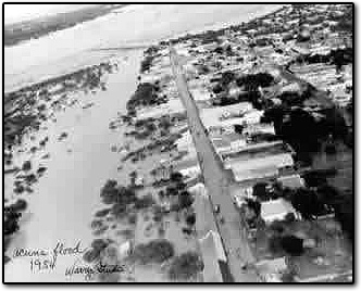

Before there were early warning systems or the Amistad Dam, a hurricane surge overwhelmed our sister city of Acuña and washed out Texas bridges.
On June 26, 1954, Hurricane Alice developed off the coast near Brownsville and made landfall within 24 hours. Because of the hurricane’s quick formation, most residents did not know about it until it was upon them.
Most of the deaths and destruction occurred in Mexico. The floodplain of the Rio Grande and the land adjacent to Arroya de Las Vacas (part of Acuña) were underwater during the flood. While the Acuña–Del Rio International Bridge sat above the water, the approaches to it were destroyed, rendering the bridge useless. The streets of Acuña were flooded, and over 10,000 people had to be evacuated to the highest ground. Helicopters and airplanes ferried potable water, food, and other supplies to Acuña for weeks until the International Bridge could be reopened.
Heavy rains near Langtry resulted in 27.10" of rain at Pandale, TX, causing terrible flooding there as well. The Rio Grande experienced its greatest rise since 1865: The river rose 30 to 60 feet at Eagle Pass and Laredo. An 86-foot wall of water rushed down the Pecos River, washing out a bridge normally 50 feet above the water level. The International Bridge at Laredo was also washed out. The 1954 flood destroyed the railroad bridge over Devils River. In less than a day, 18 inches of rain fell at Ozona, in Crockett County on Val Verde's north border. As much as 30 inches fell in locales along the Pecos River to the west. All of the runoff funneled down the Devils River, Pecos River and Rio Grande, causing much damage.


The 1954 flooding hurried the process of building a flood control dam on the middle Rio Grande. The massive dam project was initially called Diablo Dam for the nearby Devils River, but was later renamed "Amistad," the Spanish word for friendship. American President Eisenhower and Mexican President Lopez-Mateos are credited with the change of name. In July 1960, President Eisenhower signed the Amistad legislation appropriating the first monies for the dam project, and on October 24, Presidents Eisenhower and Mateos met in Ciudad Acuña. An annual celebration called Fiesta de Amistad commemorates the presidential meeting.
The Amistad Dam was a cooperative undertaking of the American and Mexican sections of the International Boundary and Water Commission. It is 12 miles upstream on the Rio Grande from Del Rio, Texas, and Ciudad Acuña, Coahuila, Mexico. On October 24, 1960, U.S. President Dwight David Eisenhower and Mexican President Lopez Mateos met in Ciudad Acuña to sign the initial agreements authorizing the construction of the dam. President Lyndon Baines Johnson met President Gustavo Diaz Ordaz on the International Bridge between the sister cities in December 1966, to finalize construction plans. President Richard M. Nixon met with President Diaz Ordaz for the dedication of Amistad Dam on September 8, 1969. The two presidents inaugurated the "Port of Mexico" facilities on the Acuña side of the dam and later conferred at "El Mirador," which at that time was a restaurant just south of the dam.
The Amistad Dam is not the only major construction project in Val Verde County. The award-winning $4 million Herbert C. Petry highway bridge spans Lake Amistad across the Devils River arm. Just over a mile in length, its 40 piers rise 240 feet above the floor of the Devils River bed. The Southern Pacific railroad link across the lake is a bridge 60 feet higher running parallel to the Petry Bridge. Further out Highway 90, which traces the route of the historic Old Spanish Trail, is the highest bridge in the State of Texas. Rising 273 feet above the bed of the Pecos River, this landmark bridge is located a short distance upstream from the intersection of the Pecos and Rio Grande Rivers. Just upstream from this bridge lies the Southern Pacific Railroad's Pecos High Bridge. Originally built in 1892, this award-winning engineering marvel was replaced in 1944. It crosses a 2,180 foot wide canyon, 321 feet above the Pecos River bottom. In this same area, a silver spike was driven to connect the final link in the southern transcontinental railroad route, named the Southern Pacific's "Sunset Route", on January 12th, 1883.
